This A3 format atlas provides giant scale mapping and type throughout. It is available in two binding styles, softback and spiral bound. Each page has been titled with its geographical location so you can turn to the page you need more easily. Wide minor roads (more than and less than 4m wide), National Trust, English and World Heritage sites, crematorium locations, and other hard-to-find places are indicated on the mapping. There are 72 city, town, and port plans including a central district map of London and a full-color ...
Read More
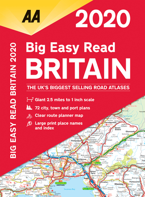
This A3 format atlas provides giant scale mapping and type throughout. It is available in two binding styles, softback and spiral bound. Each page has been titled with its geographical location so you can turn to the page you need more easily. Wide minor roads (more than and less than 4m wide), National Trust, English and World Heritage sites, crematorium locations, and other hard-to-find places are indicated on the mapping. There are 72 city, town, and port plans including a central district map of London and a full-color admin map showing all the latest unitary authority areas. Plus, scenic routes and tourist sites with satnav friendly post codes. 2.5 miles to 1 inch 1:160,000 - 1.6km to 1cm.
Read Less
Add this copy of Big Easy Read Britain 2020 Spiral Bound (Aa Road Atlas to cart. $15.24, good condition, Sold by Goldstone Books rated 4.0 out of 5 stars, ships from Ammanford, CARMS, UNITED KINGDOM, published 2019 by AA Publishing.
Choose your shipping method in Checkout. Costs may vary based on destination.
Seller's Description:
Good. All orders are dispatched within 1 working day from our UK warehouse. Established in 2004, we are dedicated to recycling unwanted books on behalf of a number of UK charities who benefit from added revenue through the sale of their books plus huge savings in waste disposal. No quibble refund if not completely satisfied.